About All Tours Jeep ToursSunrise Jeep ToursTrekking ToursSunrise ToursSunset ToursFrom Ubud ToursPrivate ToursHot Spring Tours Directions Hours & Fees
Find Tours 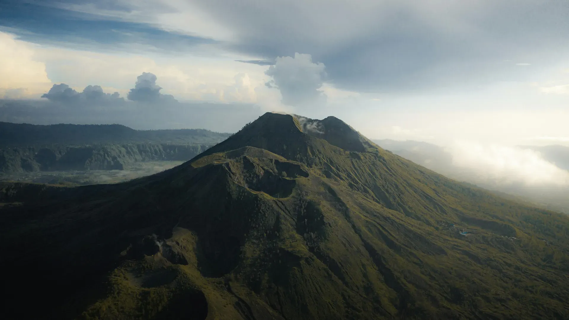
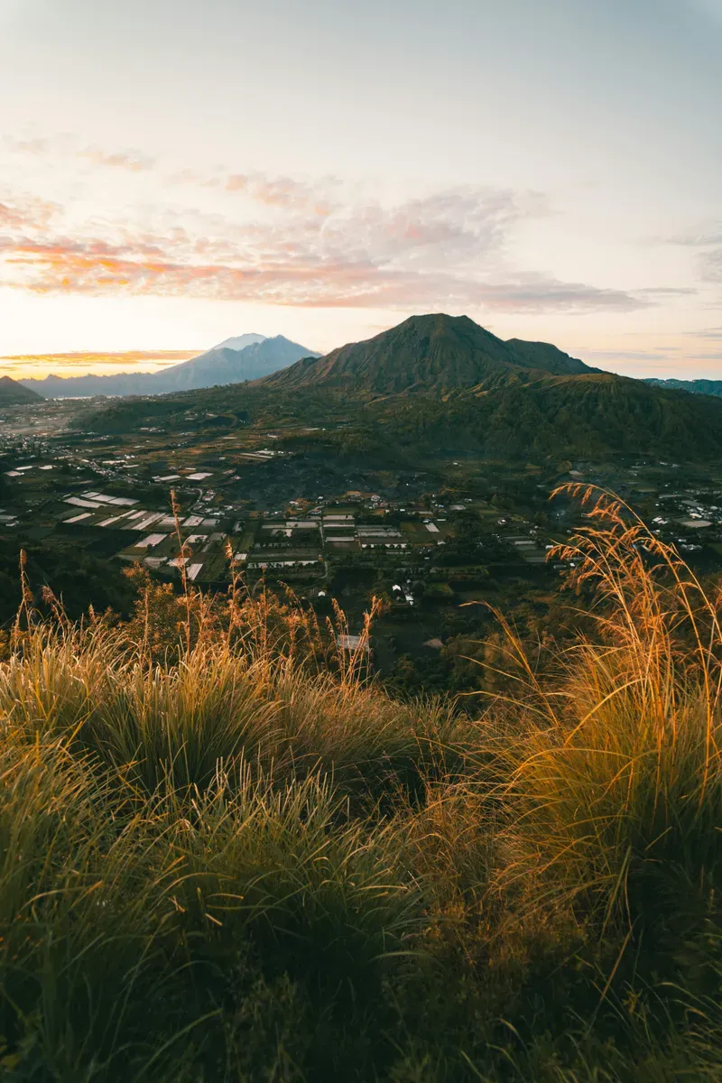
Mount Batur rises 1,717 meters above sea level in Bali's Kintamani District. This active stratovolcano centers a massive double caldera and a 16-square-kilometer crater lake.
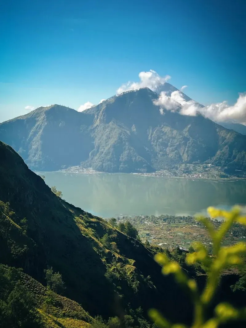
Steam vents hiss from the rocky fissures of Mount Batur, an active stratovolcano dominating northeastern Bali. The 1,717-meter central cone rises sharply from the floor of an ancient, collapsed crater. A 16-square-kilometer crescent of water, Lake Batur, hugs the southeastern edge of this depression. Hikers navigate steep paths of loose black sand in the pre-dawn darkness to reach the summit rim. Temperatures hover between 10°C and 15°C before sunrise. At the top, the horizon breaks open to reveal Mount Agung and Lombok's Mount Rinjani piercing through the morning cloud cover.
The Kintamani District surrounds the volcano with steep caldera walls and highland villages. Black lava fields from the 1963 and 1974 eruptions spill across the valley floor. These jagged basalt expanses contrast sharply with the dense green forests clinging to the outer ridges. Designated a UNESCO Global Geopark in 2012, the site draws roughly 200,000 visitors annually. Pack a moisture-wicking base layer and a windproof jacket. You will sweat profusely during the steep climb, but the cold wind at the summit will freeze that sweat while you wait for the sun.
Trekking requires planning and physical effort. The 11-kilometer round trip takes four to five hours on a well-worn but rocky trail. Most visitors depart from coastal hubs like Seminyak or Canggu around 01:30 AM, enduring a 70-kilometer, three-hour drive to the trailhead. Private cars for this route cost approximately 700,000 IDR. Travelers coming from Ubud face a shorter 39-kilometer journey, taking 1.5 hours and costing around 400,000 IDR. Shared group tours average 500,000 IDR and include transport, a guide, the 100,000 IDR entrance fee, and breakfast. Headlamps cut through the pitch-black forest during the initial ascent. The final 45 minutes demand scrambling over sharp volcanic rocks. Rain turns the volcanic ash into a slick hazard between November and March. Cloud cover frequently obscures the summit during these months. Book a local guide through the HPPGB trekking association to secure your permit and navigate the winding ascent safely. Avoid the 100,000 IDR scooter drive from Canggu in the dark; the mountain roads are winding, unlit, and frequently shrouded in thick fog. Watch out for fake guide scams along the approach roads; only book through reputable companies or the official association building at the base.
Two catastrophic collapses shaped the modern landscape of the Kintamani region. The outer caldera, measuring 13.8 by 10 kilometers, caved in approximately 29,300 years ago following a massive magma displacement beneath the earth's crust. A second eruption 20,150 years ago formed the inner 6.4 by 9.4-kilometer caldera. These violent tectonic shifts left behind the concentric rings of steep ridges that enclose the current volcano and lake. The sheer walls of the outer rim drop hundreds of meters down to the basin floor, illustrating the scale of the prehistoric explosions.
Documented volcanic activity began in 1804. Since then, 26 distinct eruptions have reshaped the central cone and surrounding valley floor. The most devastating event occurred in 1917. Rivers of lava and violent tremors destroyed 65,000 homes and leveled 2,500 temples across the district. Thousands of residents fled the caldera floor, relocating their villages to the higher, safer rims. The lava stopped just short of the original Pura Ulun Danu Batur temple, an event locals interpreted as a divine sign. Another major eruption in 1926 completely buried the village of Batur and the original temple. The local population rebuilt the temple higher up on the caldera rim, where it stands today.
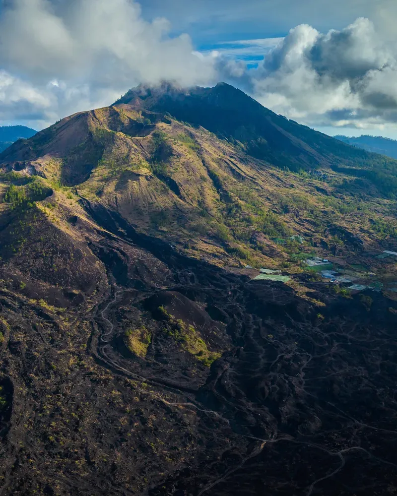
Lava flows from 1963 and 1974 created the vast black rock fields visible today at the mountain's base. The 1968 eruption added a new parasitic cone to the southern flank. Ash plumes darkened the sky during the most recent significant eruption in 2000, coating nearby villages in a thick layer of gray dust. The volcano currently maintains a Level I Normal status, monitored constantly by seismologists. Tourism replaced agriculture as the primary economic driver in the late 20th century. Local farmers transitioned into trekking guides, forming the Mount Batur Guide Association (HPPGB) to manage the influx of hikers. The 2012 UNESCO Global Geopark designation formalized conservation efforts, restricting single-use plastics and regulating trail maintenance. Check the Indonesian volcanology agency's daily reports before planning a hike, as sudden seismic activity can shut down the trails without warning.
A double-concentric caldera system defines the geography of the Kintamani highlands. The outer rim drops steeply into a massive basin, housing both the active 1,717-meter central cone and Lake Batur. This crescent-shaped body of water reaches depths of 88 meters and spans 16 square kilometers. Geothermal activity heats the groundwater along the lake's edge, feeding natural hot springs like Toya Devasya and Batur Natural Hot Spring. The water in these pools averages 38°C to 40°C, heavy with dissolved minerals from the magma chamber below. Local fishermen operate small boats across Lake Batur, navigating between floating fish farms and the steep eastern caldera walls.
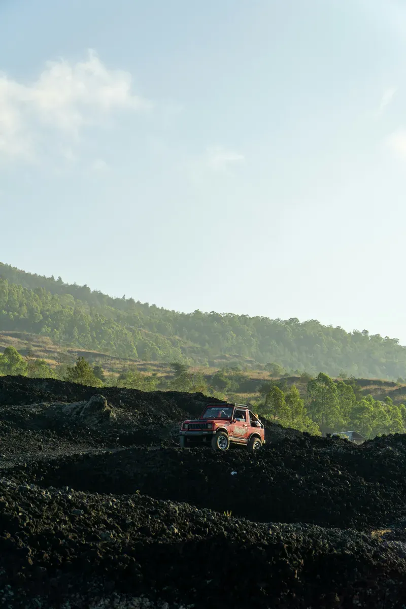
Solidified basalt from late 20th-century eruptions covers the western and southern base of the mountain. These black lava fields consist of sharp, porous AA lava rocks that crunch underfoot and trap daytime heat. The stark, vegetation-free zones stretch for kilometers, offering a harsh contrast to the surrounding tropical foliage. Above the tree line, the terrain shifts to loose volcanic sand and gravel. This material acts like ball bearings on the steep descent, causing frequent slips and minor injuries for hikers wearing inadequate footwear. Visitors who cannot manage the steep hike can hire 4WD Jeep tours. These rugged off-road vehicles bypass the hiking trail, navigating deep ruts and steep inclines to reach a designated sunrise viewpoint just below the main crater.
Active fumaroles dot the summit crater rim. Plumes of sulfurous steam escape through narrow fissures in the rock, carrying the distinct scent of rotten eggs. Guides routinely use these 90°C vents to boil eggs and steam bananas for hikers' breakfasts. The main crater measures roughly 600 meters in diameter, with sheer drops on the interior walls. Long-tailed macaques inhabit the upper elevations, scavenging near the steam vents. Secure your food and cameras, as these monkeys aggressively snatch loose items from unwary visitors. Drone pilots must coordinate with guides, as the high winds and sulfur clouds can easily down small aircraft over the crater.
Balinese Hindus revere the mountain as a sacred entity. It stands opposite Mount Agung, representing the female element in the island's spiritual geography, while Agung embodies the male. This duality maintains the cosmic balance essential to Balinese cosmology. Local belief dictates that the god Brahma resides within the volcano's fiery core. Villagers conduct regular ceremonies at the crater rim to appease the mountain spirits and prevent catastrophic eruptions. Visitors must respect the mountain's religious status. There is no formal religious dress code for the hike itself, unlike temple visits, but loud behavior and disrespecting the shrines along the trail violate local laws.
Lake Batur provides the ultimate source of water for central Bali's complex subak irrigation system. Pura Ulun Danu Batur, among the island's nine directional temples, honors Dewi Danu, the goddess of the lake. Farmers from across the island make regular pilgrimages to this temple to offer rice, fruit, and flowers. They seek the goddess's blessing for steady rainfall and fertile crops. The temple complex features towering black meru pagodas that mirror the shape of the surrounding peaks. Women balance tall towers of fruit and woven palm leaves on their heads, ascending the temple steps during major ceremonies.
The Bali Aga people of Trunyan village inhabit the lake's eastern shore. Unlike most Balinese Hindus who practice cremation, the Trunyanese lay their dead in open-air bamboo cages beneath a massive Taru Menyan tree. The tree's fragrant scent neutralizes the odor of decomposition, a phenomenon that draws curious visitors across the lake. Hire a local boat from Kedisan to reach Trunyan, but negotiate the fare clearly at the dock to avoid mid-lake price hikes. Respect the local customs by keeping your voice low and refraining from touching the skeletal remains scattered around the burial site.
Guides cook eggs by burying them in the 90°C steam vents at the summit.
Troops of long-tailed macaques live at the 1,717-meter peak and routinely steal food from hikers.
Lake Batur's water feeds the ancient irrigation networks that sustain rice terraces across central Bali.
The nearby Trunyan village leaves its deceased to decompose naturally under a fragrant Taru Menyan tree.
The volcano sits inside two massive, overlapping craters formed tens of thousands of years apart.
Visitors can bypass the physical hike by taking a 4WD off-road vehicle directly to the sunrise viewpoint.
The jagged basalt plains at the base are frozen lava rivers from the 1968 and 1974 eruptions.
Yes, it is an active stratovolcano currently classified at Level I Normal status. The last major ash eruption occurred in 2000.
The 11-kilometer round trip takes most hikers four to five hours. The ascent requires about two hours of steady climbing.
The local Mount Batur Guide Association (HPPGB) mandates guides for all hikers. This rule ensures safety on the dark trails and supports the local economy.
Temperatures drop to 10°C before dawn, requiring layered clothing and a warm jacket. Sturdy, closed-toe shoes with aggressive grip are essential for the slippery volcanic ash.
The crescent-shaped crater lake reaches a maximum depth of 88 meters. It spans 16 square kilometers across the southeastern caldera floor.
Basic facilities exist at the trailhead and occasionally at a halfway rest stop. The summit crater has no public restrooms.
April to October provides the clearest skies and driest trails. November through March brings heavy rain, making the volcanic gravel dangerously slick.
Children aged six and older with good stamina can complete the hike. Younger children should take the 4WD Jeep tour to avoid the steep, dark ascent.
The base entrance fee is 100,000 IDR. Guided sunrise trek packages typically cost between 300,000 and 600,000 IDR per group.
Altitude sickness is rare at 1,717 meters, but some hikers experience lightheadedness. Stop climbing, drink water, and inform your guide immediately if symptoms occur.
Browse verified tours with free cancellation and instant confirmation.
Find Tours